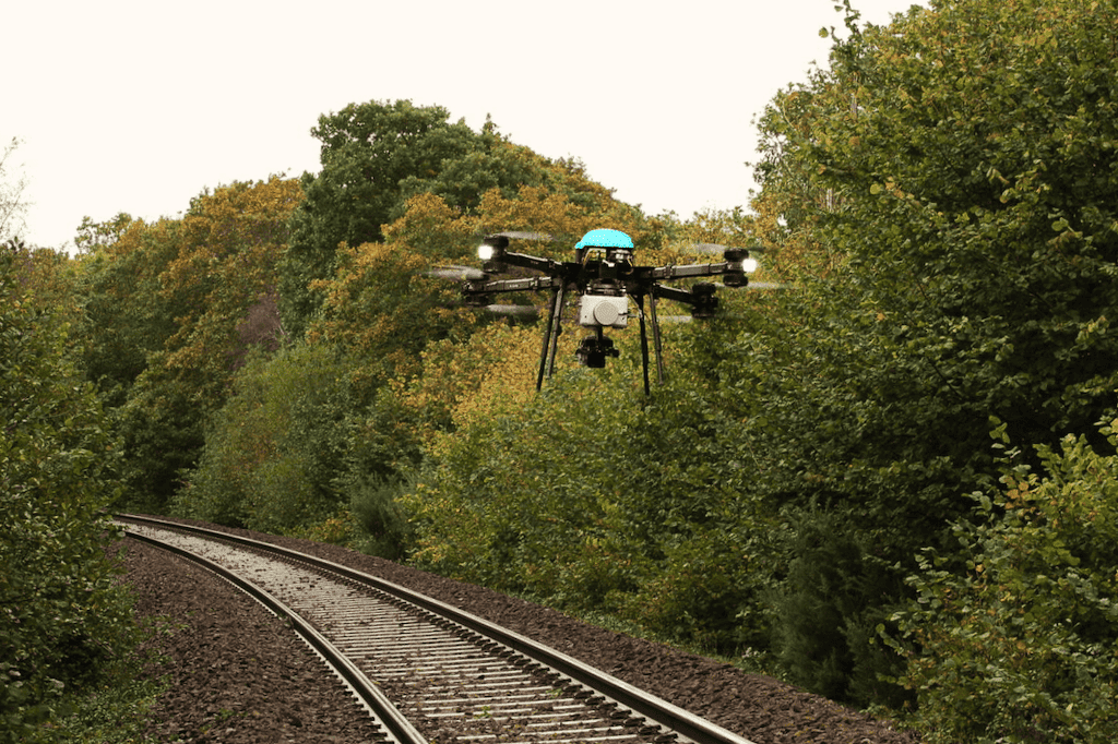
Drone Survey Services

Railway & Metro
Route Survey

High-precision drone-based surveys for railway line planning, metro corridor mapping, and track infrastructure inspection — delivering centimetre-accurate data safely, quickly, and with zero operational disruption.

Railway aerial drone survey
Route Alignment Survey Track Inspection Corridor Mapping Encroachment Detection Bridge Inspection Station Area Planning DEM / DTM Generation Route Alignment Survey Track Inspection Corridor Mapping Encroachment Detection Bridge Inspection Station Area Planning DEM / DTM Generation
Service Overview

Why Drone Survey for
Railway & Metro?

Railway corridor surveys have traditionally required large teams working alongside active tracks — a dangerous, slow, and costly approach. Our UAV-based survey method captures the same data from the air, with far greater speed, safety, and accuracy, including areas inaccessible to ground teams.

A 20 km railway corridor survey that takes ground teams 2–3 weeks can be completed by our drone fleet in 3–4 days — including data processing and report delivery, with zero track possession required.

  • Survey active tracks with zero possession or blockage
  • 40 km corridor coverage per day
  • Sub-5 cm accuracy with RTK/PPK GPS
  • Complete 3D model for alignment & grade analysis
  • Encroachment detection along ROW boundary
  • Compatible with IR, RVNL & DMRC standards
Railway aerial view
Applications

Where We Apply This Service

Our railway & metro drone survey is used across planning, construction, and maintenance phases.

New Railway Line Planning

Greenfield route surveys for new railway lines — terrain mapping, alignment study, feasibility analysis, and complete pre-engineering survey packages.

Route Study Alignment
Metro Corridor Mapping

Elevated and underground metro route surveys for DMRC, CMRL, and state metro corporations — supporting DPR preparation and detailed design.

DPR Support Metro
Track Safety Inspection

Regular aerial inspection of existing track, ballast condition, drainage, slope stability, and embankment erosion — without shutting down operations.

Safety Track Audit
ROW Encroachment Detection

Precise mapping of railway right-of-way (ROW) to detect encroachments, unauthorised structures, and vegetation overgrowth along the corridor.

ROW Mapping Encroachment
Bridge & Viaduct Inspection

Close-proximity inspection of railway bridges, viaducts, and tunnels portals for crack detection, spalling, and structural condition assessment.

Inspection Structural
Station Area & Yard Planning

Detailed aerial survey of station areas, goods sheds, marshalling yards, and maintenance depots for capacity planning and redevelopment projects.

Station Yard Planning
How It Works

Our Survey Process

Our railway survey workflow is designed for zero operational disruption — flights are conducted outside traffic block periods where required.
01
Scope & Corridor Definition

We define the survey corridor extent, chainage limits, accuracy requirements, and deliverable specifications in consultation with your project team.

02
Airspace & Safety Clearance

DGCA airspace permissions, railway department NOC, and safety protocols are secured before any flight operations begin near operational tracks.

03
GCP Placement & Base Setup

Ground Control Points are placed at intervals along the corridor and co-ordinated using DGPS/Total Station for accurate georeferencing of all outputs.

04
UAV Flight Operations

Automated corridor flights capture 70–80% overlap imagery with RTK positioning. Multiple UAVs can be deployed for long corridors to maintain schedule.

05
Data Processing & Model Generation

Photogrammetric processing generates ortho-images, DEMs, 3D point clouds, and cross-section profiles of the entire railway corridor.

06
Report Delivery & Integration

All outputs are packaged in IR/DMRC compatible formats and delivered within 48–72 hours with a complete accuracy and methodology report.

What You Get

Survey Deliverables

Orthomosaic Map

High-res georeferenced image mosaic

DEM / DTM

Digital Elevation & Terrain Models

3D Point Cloud

LAS/LAZ corridor point cloud

L-Section / X-Section

Longitudinal & cross-section profiles

ROW Mapping

Right-of-Way boundary delineation

Survey Report

Full accuracy & compliance report

Technical Specs

Equipment & Accuracy

UAV Platform: Fixed-wing & multi-rotor with RTK/PPK GPS
Sensor: 20MP RGB camera
Horizontal Accuracy: ±3–5 cm with GCPs
Vertical Accuracy: ±5–8 cm with GCPs
GSD: 3–5 cm/pixel at survey altitude
Coverage Rate: 30–40 km corridor/day
Output Formats: GeoTIFF, DXF, DWG, LAS, SHP, PDF
Standards: IR, RVNL, DMRC, CMRL compliant
Frequently Asked

Railway Survey FAQs

Can you survey near active railway tracks?
Yes. We operate under DGCA regulations at safe altitudes above operational tracks. A railway department NOC is obtained before operations, and all safety protocols are strictly followed.
Do you require a traffic block for drone survey?
No traffic block is required for standard aerial mapping. For close-proximity bridge or structure inspections, brief maintenance windows may be coordinated with minimal disruption.
How do you handle dense urban metro corridors?
We use compact multi-rotor UAVs with precise waypoint navigation for tight urban corridors. Airspace coordination with AAI is handled by our team for operations near airports.
Are your outputs compatible with Indian Railways software?
Yes. Deliverables are provided in AutoCAD, MicroStation, and GIS formats compatible with IR, RVNL, DMRC, and all major DPR consultants' software environments.
Can you detect encroachments along the ROW?
Yes. Using georeferenced imagery and GIS analysis, we can identify and map all structures, cultivations, and encroachments within the railway ROW with precise coordinates for legal documentation.
Start Your Project

Need a Railway
Drone Survey?

Share your corridor details and receive a customised quotation within 24 hours. DGCA licensed, pan-India operations.