Transmission & Distribution Survey
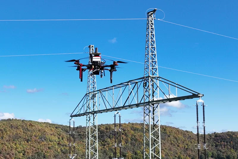
PowerLine Drone
Survey & Inspection

Safe, rapid aerial surveys for EHV transmission lines, distribution networks, substations, and towers — detecting conductor sag, vegetation encroachment, hardware faults, and corrosion with LiDAR and thermal sensors, eliminating the need for dangerous manual inspection at height.

PowerLine drone inspection
Conductor Sag Survey Vegetation Encroachment Tower Inspection Thermal Fault Detection ROW Mapping Insulator Inspection LiDAR Point Cloud Conductor Sag Survey Vegetation Encroachment Tower Inspection Thermal Fault Detection ROW Mapping Insulator Inspection LiDAR Point Cloud
Service Overview

Why Drone Survey for
PowerLine Corridors?

Traditional power line inspection requires helicopter patrols, linemen climbing live towers, and patrollers walking remote terrain — all dangerous, slow, and expensive. Our drone surveys cover hundreds of kilometres per day from a safe distance, capturing LiDAR point clouds for precise sag and clearance measurements, thermal imagery for hotspot detection, and 4K video for hardware inspection — with lines live and no outage required.

A 500 km transmission line inspection that takes a helicopter team 5–7 days at high cost can be completed by our drone fleet in 2–3 days — with LiDAR sag data, thermal hotspots, and vegetation clearance maps delivered together.

  • 300+ km transmission corridor per day
  • LiDAR for precise conductor sag & clearance measurement
  • Thermal imaging for hotspot and joint fault detection
  • Vegetation clearance analysis and encroachment mapping
  • Tower condition and hardware inspection
  • CEA, PGCIL, and state TRANSCO standard compliant
Voltage Coverage

Lines We Survey

Our drone survey capability covers all voltage levels — from rural distribution to 765 kV EHV national grid transmission.

765kVEHV Transmission
400kVHV Transmission
220kVSub-Transmission
132kVSub-Transmission
33kVDistribution
11kVRural Distribution
What We Detect

Faults & Anomalies

Thermal Hotspots — Joints & Connectors

Overheating compression joints, clamps, and connectors detected via thermal imaging — a leading indicator of imminent failure and arc flash risk.

Conductor Sag & Clearance Violations

LiDAR-measured conductor sag at every span — identifies sections where minimum ground, road, or vegetation clearance is violated per CEA regulations.

Vegetation Encroachment

Trees and vegetation approaching minimum clearance distances — precise identification of which spans require trimming before the next season's growth.

Damaged & Broken Insulators

Close-range visual and UV inspection of insulator strings — broken discs, contamination, and tracking marks that reduce creepage distance and risk flashover.

Tower Structural Damage

Bent members, missing bolts, corrosion, foundation cracks, and anti-climbing guard damage on lattice towers detected from close-range RGB inspection.

ROW Encroachment — Structures

New constructions, buildings, antennas, and unauthorised structures within the transmission line ROW that violate CEA clearance norms.

Conductor Damage & Broken Strands

Surface damage, broken conductor strands, bird caging, and armour rod displacement detected using close-range high-resolution zoom camera imagery.

Earthwire & OPGW Issues

Earthwire slack, vibration damper loss, OPGW slack or splice box damage detected along transmission line corridors.

Applications

PowerLine Survey Applications

Transmission Line Route Survey

Pre-construction route survey for new EHV/HV transmission lines — terrain mapping, tower spotting studies, forest and agricultural crossing optimisation, and ROW planning.

Route StudyTower Spotting
Annual Maintenance Inspection

Complete annual inspection of transmission and distribution lines — tower condition, hardware, conductors, and vegetation clearance for preventive maintenance planning.

AnnualPreventive
Thermal Hotspot Patrol

Targeted thermal drone patrol to find overheating joints, connectors, and hardware before they cause line tripping, fire, or arc flash incidents.

ThermalHotspot
Vegetation Management Survey

Pre-monsoon vegetation clearance survey — identifying trees and branches approaching minimum clearance, generating a span-by-span tree trimming priority list.

TrimmingPre-Monsoon
Post-Storm Damage Assessment

Rapid aerial assessment after cyclones, storms, and floods — mapping tower collapses, conductor breaks, and fallen trees for priority restoration sequencing.

DamageRestoration
Substation Aerial Inspection

Aerial thermal and RGB inspection of substation equipment — transformers, busbars, switchgear, cable trays, and gantry structures for condition monitoring.

SubstationThermal
How It Works

Inspection Process

Power line operations require strict safety protocols — all our operations follow CEA, PGCIL, and utility-specific clearance procedures.
01
Utility Coordination & Safety Clearance

We coordinate with the transmission/distribution utility, obtain line patrol permissions, and follow CEA minimum safe distance protocols. No outage or shutdown is required for standard aerial survey.

02
Sensor Configuration

LiDAR for sag and vegetation clearance, thermal for hotspots and joint inspection, high-resolution zoom RGB for hardware and insulator inspection — configured per survey objective.

03
Corridor Flight Operations

UAV flies the line corridor at safe distance maintaining CEA minimum clearances. Tower-by-tower inspection flights are added for close-range hardware and conductor assessment.

04
LiDAR & Point Cloud Processing

LiDAR point cloud is classified into conductors, ground, vegetation, and structures. Conductor sag, ground clearance, and vegetation-to-conductor distances are computed for every span.

05
Fault & Anomaly Classification

Thermal anomalies, structural defects, vegetation violations, and ROW encroachments are classified by type and severity. GPS coordinates are assigned to every finding.

06
Corridor Report Delivery

Complete inspection report with sag profile, hotspot map, vegetation clearance analysis, tower condition ratings, and GPS-tagged fault inventory — delivered within 48–72 hours.

What You Get

Survey Deliverables

LiDAR Point Cloud

Classified corridor point cloud (LAS)

Sag Profile

Span-wise conductor sag chart

Thermal Report

Hotspot & joint anomaly analysis

Vegetation Map

Clearance violation map by span

Fault Location Map

GPS-tagged fault & anomaly map

CEA Report

Standards-format inspection report

Technical Specs

Equipment & Accuracy

UAV: Fixed-wing for corridor, multi-rotor for towers
LiDAR: Livox/Hesai UAV LiDAR, 200+ pts/m²
Thermal: FLIR 640×512, ±0.5°C sensitivity
Visual: 20MP
Sag Accuracy: ±5 cm conductor position
Coverage: 200–300 km corridor/day
Formats: LAS, PDF, KMZ, GeoTIFF, Excel, TIFF
Standards: CEA, PGCIL, POSOCO, IS 5613 compliant
Frequently Asked

PowerLine Survey FAQs

Can you fly near live high-voltage transmission lines?
Yes. Our pilots are trained in the specific risks of operating near energised lines. We maintain CEA-prescribed minimum safe distances during corridor patrol and use non-conductive UAV platforms. All operations are coordinated with the utility control room.
Is a line shutdown required for drone inspection?
No. Standard aerial survey and inspection is conducted with lines energised and in service. This is one of the biggest advantages over traditional inspection — no outage, no revenue loss, no customer impact.
How accurate is LiDAR sag measurement?
Our UAV LiDAR achieves ±5 cm conductor position accuracy — sufficient for clearance compliance verification per CEA regulations. The system detects every span where ground or vegetation clearance is below the prescribed minimum.
Can you detect internal conductor faults?
Thermal imaging reliably detects surface temperature anomalies from internal faults — poor joints, corroded connectors, and failing hardware show elevated temperatures. True internal core faults require resistivity testing, which we can recommend as a follow-up action.
Do you survey distribution lines in addition to transmission?
Yes. We survey all voltage levels from 765 kV EHV grid to 11 kV rural distribution networks. Distribution line surveys use optimised lower-altitude flight profiles to detect broken cross-arms, damaged poles, and vegetation issues at 11/33 kV level.
Start Your Inspection

Need a PowerLine
Drone Survey?

Share your line length and voltage level — get a custom quotation within 24 hours. No outage needed.