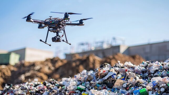
Volumetric Drone Survey

Dump Yard Survey
& Volume Calculation

Accurate, fast, and safe drone-based volumetric surveys for dump yards, waste dumps, overburden piles, stockpiles, and landfills — replacing manual survey teams with 3D aerial mapping that delivers precise volume calculations in hours.

Dump yard aerial survey
Volume Calculation Stockpile Inventory OB Dump Mapping Waste Quantification Cut & Fill Analysis 3D Surface Model Slope Monitoring Volume Calculation Stockpile Inventory OB Dump Mapping Waste Quantification Cut & Fill Analysis 3D Surface Model Slope Monitoring
Service Overview

Drone Volumetrics for
Dumps & Stockpiles

Manual volumetric surveys of dump yards, overburden dumps, and waste piles are slow, dangerous for survey staff, and often inaccurate due to inaccessible areas. Our drone survey maps the complete 3D surface in hours — delivering accurate volume calculations using TIN, prismoidal, or bulk density methods, with a full 3D model of the dump.

A dump yard volume survey that takes a 3-person ground team 3–5 days (with significant safety risk) is completed by our drone in 2–4 hours — with ±1% volume accuracy and no personnel entering the hazardous dump area.

  • ±1–3% volume accuracy using TIN/Grid methods
  • Complete 3D surface model of entire dump
  • Slope angle measurement for stability monitoring
  • Change detection between repeat surveys
  • Compatible with IBM, MOEF, and waste management reporting
  • No manned entry into unsafe dump areas
Traditional
3–5
Days
Manual team, safety risk, limited access
VS
Drone
2–4
Hours
Full 3D model, ±1% accuracy, zero risk
Dump yard aerial
Applications

Dump Types We Survey

Our volumetric drone survey service covers all dump types across mining, construction, waste management, and industrial sectors.

Overburden (OB) Dump Survey

Mining overburden dump volume calculation for IBM compliance — monthly and quarterly volumetric surveys with progressive dump plans, slope analysis, and reclamation monitoring.

IBMOB Dump
Stockpile Volume Inventory

Rapid inventory of material stockpiles — coal, iron ore, limestone, aggregate, sand — for production accounting, dispatch reconciliation, and inventory management.

StockpileInventory
Municipal Waste Landfill Survey

Landfill capacity monitoring for urban local bodies — current waste volume, remaining airspace calculation, and slope stability monitoring for safe and compliant waste management.

LandfillULB
Construction Earthwork & Spoil

Earthwork volume verification for construction sites — excavated spoil dumping, fill placement, embankment volume, and contractor billing verification for project managers.

EarthworkConstruction
Fly Ash & Industrial Waste Dump

Fly ash pond and industrial waste dump volume surveys for NTPC, thermal power plants, and industries — compliance monitoring and capacity planning.

Fly AshThermal
Tailing Dam & Slurry Pond Survey

Safe aerial survey of hazardous tailing dams and slurry ponds — capacity, beach slope, decant pond, and freeboard monitoring without any manned entry risk.

TailingsSlurry
How It Works

Volume Calculation Process

From flight to volume report in 24–48 hours — our streamlined process delivers accurate results fast.
01
Reference Surface Definition

We establish the base reference surface (original ground level, last survey surface, or sea level datum) against which the current dump volume will be calculated.

02
GCP & Control Point Setup

Ground control points are established at the dump perimeter using DGPS and tied to the site coordinate system for accurate georeferencing of all outputs.

03
UAV Survey Flight

Automated high-overlap flight covers the entire dump area. Dense imagery is captured at 70–80% forward and side overlap for complete 3D surface reconstruction.

04
3D Surface Model Generation

High-density point cloud and 3D mesh are generated from the imagery. The dense surface model accurately represents the complex geometry of dump slopes and crests.

05
Volume Computation

Volume is calculated using TIN (Triangulated Irregular Network) method between the current surface and reference surface. Results are verified using prismoidal method for cross-check.

06
Volume Report & Deliverables

Complete volumetric report with calculated volume (m³ and tonnes), 3D model, orthomosaic, slope map, and change detection comparison — delivered within 24–48 hours.

What You Get

Survey Deliverables

Volume Report

Certified m³ & tonnage report

3D Surface Model

High-density dump surface mesh

Orthomosaic

High-res top-view dump image

Contour Map

Dump contour & slope map

Change Detection

Before/after volume comparison

Slope Analysis

Slope angle & stability report

Technical Specs

Equipment & Accuracy

UAV: Multi-rotor with RTK GPS, autonomous flight
Camera: 20MP RGB
Volume Accuracy: ±1–3% of total volume
Position Accuracy: ±5–10 cm with GCPs
GSD: 3–8 cm at survey altitude
Coverage: 100–200 hectares/day
Volume Methods: TIN, Prismoidal, Bulk Density
Output Formats: PDF, DXF, LAS, GeoTIFF, CSV, Excel
Frequently Asked

Volume Survey FAQs

How accurate is drone volume calculation?
With GCP-controlled photogrammetry, our surveys achieve ±1–3% volume accuracy — significantly better than manual survey methods which typically achieve ±5–10%. For mining compliance, this exceeds IBM prescribed accuracy requirements.
What is the reference surface used for volume calculation?
The reference surface can be the original ground surface (from a baseline survey), a previous survey surface (for period volume change), a flat plane at a defined elevation, or any custom surface based on project requirements.
Can you survey active dump areas with moving machinery?
Yes, with coordination. We typically survey during brief operational pauses or at shift changeover to minimise equipment interference. Alternatively, we can coordinate with operators to avoid the active face during the survey flight.
How is the volume report certified?
Volume reports include full methodology documentation, GCP accuracy reports, and can be co-signed by a licensed mine surveyor or civil engineer for IBM, statutory, and contractual submission purposes.
Can you do monthly repeat surveys for trend monitoring?
Yes. We offer periodic survey contracts — monthly, quarterly, or as required. Repeat surveys use the same GCP network for consistent change detection, and we provide cumulative volume tracking reports over time.
Get Your Volume Calculated

Need Dump Yard
Volume Calculation?

Share your site details — get a custom quotation within 24 hours. Fast turnaround, certified reports.